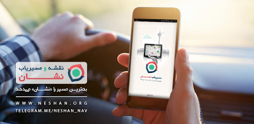
نقشه و مسیریاب نشان با استفاده از جیپیاس و در نظر گرفتن ترافیک آنلاین مانند نمونههای خارجی سریعترین و کمترافیک ترین مسیر را به شما پیشنهاد کرده و در طول مسیر هشدار نزدیک شدن به دوربین کنترل سرعت، پلیس را به شما اعلام میکند. امکاناتی مانند نمایش آلودگی هوا در شهرهایی که ایستگاه سنجش آلودگی هوا دارند، اعلام سرعتگیرهای مسیر، مسیریابی با در نظرگرفتن طرحهای ترافیک و کنترل آلودگی هوا، مسیریابی ترکیبی اتوبوس و مترو، مسیریابی موتور و ... باعث شده نشان برای بسیاری از کاربران ایرانی، از جمله رانندگان تاکسیهای اینترنتی(اسنپ و تپسی) مزیتهای اختصاصی بسیاری به نسبت سایر سرویسهای نقشه و مسیریاب داشته باشد.
ویژگیها و مزیتهای اصلی مسیریاب نشان :
نمایش ایستگاههای سنجش آلودگی هوا در تمام شهرهایی که این ایستگاه را دارند مانند تهران، مشهد، کرج، اصفهان، تبریز، اهواز، اراک و ...
نقشه آفلاین و کامل ایران به همراه بیشترین جزئیات و ترافیک آنلاین کلیه شهرها
امکان انتخاب بهترین و ارزانترین روش رسیدن به مقصد با مسیریابی ترکیبی اتوبوس و مترو
قابلیت «کی، کجاست؟» برای اشتراکگذاری و مشاهده موقعیت آنلاین دوستان و همسفران بر روی نقشه
نقشه جهان با امکان مسیریابی به تمامی نقاط مورد نظر
سخنگوی فارسی با قابلیت بیان نام خیابانها برای بینیاز شدن از مشاهدهی نقشه
پیدا کردن مکانهای عمومی اطراف مانند رستوران، پمپ بنزین، خودپرداز، هتل و …
امکان جستجو بدون نیاز به تایپ (تشخیص گفتار فارسی)
مسیریابی با در نظرگرفتن طرحهای ترافیک و کنترل آلودگی هوا برای کنترل عدم ورود ناخودآگاه به داخل طرح ها(تهران، مشهد، اصفهان)
قابلیت انتخاب مسیر سرراست در تنظیمات مسیریابی نشان
هشدار حضور پلیس، دوربین کنترل سرعت، سرعتگیر و ترافیک
تشخیص موقعیت مکانی دقیق کاربران با استفاده از GPS
نقشه و مسیریاب نشان توسط شرکت راژمان، مجری پروژههای نقشهی همراه مشهد، نقشهی همراه تهران، نقشهی همراه اصفهان، شیراز، تبریز، قم، اهواز، کرج، قزوین، اراک، کاشان، رشت، گرگان، همدان، کیش و قشم توسعه یافته است. با نقشه و مسیریاب نشان همه جا رو خودتون بلد هستید و به راه بلد نیاز ندارید.
برای ارتباط با نشان میتونید از کانالهای زیر هم استفاده کنید:
* وبسایت نقشه و مسیریاب نشان: neshan.org
* وبلاگ نشان: neshan.blog
* ایمیل: support@neshan.org
* پشتیبانی تلگرام نشان: @neshan_admin
* اینستاگرام نشان: instagram.com/neshan_nav
The GPS map and router suggests the fastest and least traffic route using GPS, taking into account online traffic such as foreign examples, and notifies the police during the warning lane approaching the speed camera. Features such as air pollution display in cities with air pollution monitoring stations, announcement of route accelerators, routing considering traffic plans and air pollution control, combined bus and subway routing, engine routing, etc. have made the sign for many Iranian users, Internet taxi drivers (Snap and Tepsi) have many special advantages over other mapping and routing services.
The main features and advantages of the badge router:
Display of air pollution monitoring stations in all cities that have this station, such as Tehran, Mashhad, Karaj, Isfahan, Tabriz, Ahvaz, Arak, etc.
Offline and complete map of Iran with the most details and online traffic of all cities
Ability to choose the best and cheapest way to reach the destination with a combined bus and subway routing
"Who, where?" To share and view the online position of friends and fellow travelers on the map
World map with the possibility of navigating to all desired points
Persian speaker with the ability to say the names of the streets to avoid the need to view the map
Find nearby public places such as restaurants, gas stations, ATMs, hotels and more.
Ability to search without typing (Persian speech recognition)
Routing by considering traffic plans and air pollution control to control the unconscious entry into the plans (Tehran, Mashhad, Isfahan)
Ability to select the route directly in the badge routing settings
Police presence alert, speed camera, accelerator and traffic
Detect the exact location of users using GPS
The map and the route navigator have been developed by Rajman Company, the executor of mobile map projects in Mashhad, mobile map of Tehran, mobile map of Isfahan, Shiraz, Tabriz, Qom, Ahvaz, Karaj, Qazvin, Arak, Kashan, Rasht, Gorgan, Hamedan, Kish and Qeshm. . With a map and a navigator, you know the sign everywhere and you do not need to know the way.
You can also use the following channels to communicate with the logo:
* Website map and navigation logo: neshan.org
* Blog logo: neshan.blog
* Email: support@neshan.org
* Telegram support badge: @neshan_admin
* Instagram logo: instagram.com/neshan_nav